 |
GOLD PROSPECTING Global Discovery, Natural Gold, Diamonds & Precious Metals Prospecting Professional |
|---|
Professional gold consultant
Gold Silver and Minerals Surveyed Worldwide
|
YOU CAN PURCHASE FURTHER DETAILS OF ANY OF THESE
DEPOSITS WHICH WILL INCLUDE THE LOCATIONS, COORDINATES,
QUANTITIES AND ALL THE DEPTH COUNTS BY REMOTE MAP SURVEYING
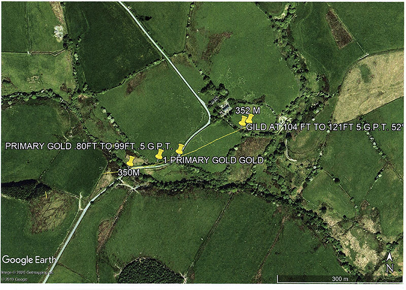
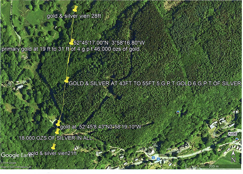
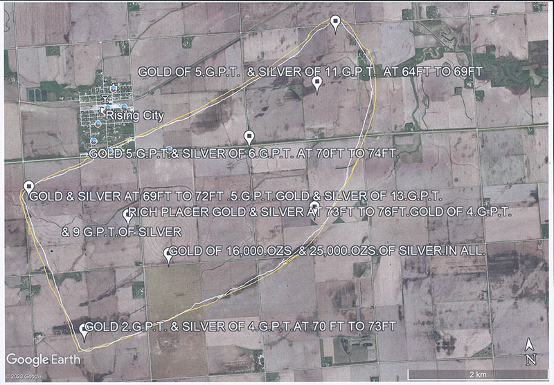
USING GOOGLE EARTH MAP'S WHY SPEND A FORTUNE ON TRYING TO FIND THE SOURCES ON SITE WHEN I CAN LOCATE THE AREAS VIA REMOTE MAP SURVEYING WHICH HAS BEEN PROVEN WITH MY PAST RECORD OF MY SKILLS. TITANIUM LIST SCOTLAND Titanium 7 deposits out of many from Northern Scotland. 1. Primary titanium deposit – estimated depth 64ft to 72ft, estimated quantity recoverable 45,000 ozs 2. Rich primary deposit – estimated depth 100ft to 117ft, estimated quantity recoverable 31,000 ozs in total. On this occasion is it 19 grams per tonne 3. Primary deposit – estimated depth 80ft to 101ft, 26,300 ozs, 21 grams per tonne. 4. Primary deposit – estimated 93ft to 112ft, 23,000 ozs in all, 21 grams per tonne 5. Rich titanium deposit – estimated depth of 53ft to 73ft, 62,000 ozs 6. Primary deposit – estimated depth 57ft to 76ft, estimated 43,000 ozs 7. Primary deposit – estimated depth of 67ft to 76ft, estimated 70,000 ozs UNITED STATES OF AMERICA Titanium – 8 deposits out of many more 1. Rich primary – estimated depth of 53ft to 64ft, estimated recoverable 92,000 ozs 2. Rich primary – estimated depth 77ft to 86ft, estimated 85,000 ozs recoverable 3. Rich primary – estimated depth 63ft to 73ft, estimated 72,000 ozs recoverable 4. Rich primary – estimated depth 48ft to 60ft, estimated 71,000 ozs recoverable 5. Rich primary – estimated depth 40ft to 49ft, estimated 79,000 ozs 6. Rich primary – estimated depth 76ft to 89ft, estimated 93,000 ozs recoverable 7. Rich primary – estimated depth 78ft to 88ft, estimated 72,000 ozs recoverable 8. Rich primary – estimated depth 64ft to 72ft, estimated 62,000 ozs recoverable LIST OF PRIMARY SILVER DEPOSITS IN WALES 1. Primary silver – estimated depth 65ft to 81ft, estimated recoverable 32,000 ozs in all 2. Rich primary silver – estimated depth 94ft to 112ft, 21 grams per tonne, estimated recoverable 81,000 ozs 3. Primary silver – estimated depth 54ft to 64ft – 21 grams per tonne, estimated recoverable 97,000 ozs 4. Primary silver – estimated depth 40ft to 55ft, 18 grams per tonne, estimated recoverable 65,000 ozs in all 5. Rich primary silver – 97ft to 115ft, 18 grams per tonne, estimated recoverable 64,000 ozs in all 6. Rich primary silver – estimated depth 26ft to 31ft, 11 grams per tonne, estimated recoverable 39,000 ozs 7. Primary silver – 81ft to 92ft, 16 grams per tonne, estimated recoverable 81,000 ozs in all IN SCOTLAND 1. Primary silver – Estimated depth 115ft to 133ft, 22 grams per tonne, estimated recoverable 98,000 ozs in all 2. Rich primary silver – estimated 92ft to 111ft, 22 grams per tonne, estimated recoverable 38,000 ozs 3. Primary silver – estimated depth 63ft to 80ft, 19 grams per tonne, estimated recoverable 92,000 ozs 4. Primary silver – estimated depth 78ft to 83ft, 21 grams per tonne, estimated recoverable 35,000 ozs in all 5. Primary silver – 74ft to 93ft, 19 grams per tonne, estimated recoverable 99,000 ozs in all 6. Rich primary silver – estimated depth 93ft to 112ft, 23 grams per tonne, estimated recoverable 99,000 ozs in all 7. Primary silver – estimated depth 63ft to 77ft, 23 grams per tonne, estimated recoverable 108,000 ozs 8. Primary silver – estimated depth 93ft to 108ft, 21 grams per tonne, estimated recoverable 96,000 ozs 9. Rich primary silver – estimated depth 108ft to 117ft, 20 grams per tonne, estimated recoverable 41,000 ozs in all 10. Primary silver – estimated depth 68ft to 76ft, 22 grams per tonne, estimated recoverable 95,000 ozs in all 11. Rich primary silver – estimated depth 60ft to 73ft, 20 grams per tonne, estimated recoverable 93,000 ozs 12. Primary silver – estimated depth 99ft to 116ft, 23 grams per tonne, estimated recoverable 120,000 ozs 13. Rich primary silver – estimated depth 85ft to 99ft, 21 grams per tonne, estimated recoverable 96,000 ozs IN NORTH AMERICA 1. Primary silver – estimated depth 93ft to 111ft, 19 grams per tonne, estimated recoverable 112,000 ozs 2. Primary silver – estimated depth 82ft to 102ft, 21 grams per tonne, estimated recoverable 114,000 ozs 3. Primary silver – estimated depth 78ft to 99ft, 21 grams per tonne, estimated recoverable 98,000 ozs in all 4. Primary silver – estimated depth 103ft to 119ft, 21 grams per tonne, estimated recoverable 101,000 ozs 5. Primary silver – estimated depth 132ft to 141ft, 22 grams per tonne, estimated recoverable, 60,000 ozs in all 6. Primary silver – estimated depth 113ft to 131ft, 23 grams per tonne, estimated recoverable 99,000 ozs 7. Primary silver – e stimated depth 63ft to 79ft, 22 grams per tonne, estimated recoverable 76,000 ozs in all 8. Primary silver – estimated depth 111ft to 122ft, 23 grams per tonne, estimated recoverable 105,000 ozs in all 9. Primary silver – estimated depth 114ft to 124ft, 21 grams per tonne, estimated recoverable 113,000 ozs in all 10. Primary silver – estimated depth 80ft to 97ft, 19 grams per tonne, estimated recoverable 97,000 ozs These 3 Google Earth maps below are images where map dowsing shows the particular load deposits of primary gold and silver in this case. The maps show the direction of the load, the estimated volume recoverable i.e. Primary gold & silver, and also the quantities in grams per tonne. Each primary load is shown by one single yellow line representing one load which also gives you the shape and direction of that particular load.. |
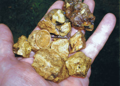
the coin in the hand is a gold sovereign